
Click on: FLSMv2.71 The model will open in a new page (it is still under construction).
See instructions below (more information will be coming soon).
Farlain Lake Systems Model (FLSM)
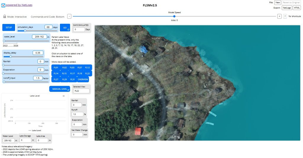
- For a simple example, click on SETUP,
- Then select a viewport (one of the small blue squares, e.g., FL22, shown above), this can be changed on the fly.
- Then use the slider (or type in) a “Rainfall” amount, e.g., 15mm (this can be changed on the fly) – make sure the amount shows up in the monitor.
- Select the number of days for the ‘event’ (e.g., for rainfall, evaporation, etc.).
- Make sure the ‘display delay’ slider is set around 1, or the simulation will occur to fast to see what is happening,
- Then click on “GO” and the water level should rise and/or fall depending of the rainfall/evaporation set. The amount accumulated will change as rainfall, and evaporation values change.
- A simulation/scenario will terminate when the days selected occurs or the flooding level reaches 212m. If you want to continue on, re-set the next amount of days and select GO, or click on the SETUP button to start a new simulation/scenario.
Regarding elevations & imagery
About the water level slider:
– 2022 depicts the LiDAR 2022imagery spring elevation water level of 209.162m.
– 2026 is approximately 210m at May/June (**verification is needed).
The underlying imagery is SCOOP 2018 (spring). SCOOP 2013 and 2023 is available, but 2018 depicted more detail.
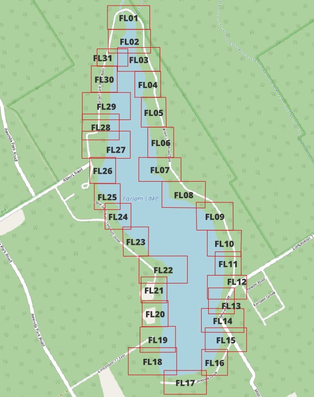
The above depicts the viewports. At the present time only 13 are available.
FL01, 2, 3, 7, 12, 14, 15, 17, 18, 22,2 7, 29, & 31.
The ‘Farlain Lake Systems Model’ FLSM is an ‘agent‑based model’ (ABM) that is structured to incorporate system components about the lake basin (e.g., see Outline 1 below). The model runs simulations of the complex interaction of factors in the system that may assist in explaining the change in lake water levels and assisting with the “what-ifs” in predicting levels. This information may then be analyzed and mapped to assist with flooding mitigation ‘if & where’ as needed.
The web‑based version of the FLSM is available for anyone to explore. The web version lets you set variables – for example, lake level, rain, run-off, evaporation, and how long you want the model to run for (in increments of time). The model will have a short learning video to walk you through how it works (under construction).
How plan is to include various factors as shown in Outline 1.
Outline 1
Example structure of the model, where water level is one component of the overall system:
├── Climate
├── Watershed
├── Groundwater
├── Surface Water
├── Lake Level
├── Shoreline Processes
└── Management Scenarios
The plan to create the Farlain Lake Systems Model (FLSM) will have various modules:
├── Climate Module
├── Snowpack Module
├── Watershed Runoff Module
├── Groundwater Module
├── ** Lake Storage & Water Balance Module
├── Storage–Elevation Module
├── Shoreline Impact Module
├── Water Quality Module
├── Scenario & Climate Change Module
└── Visualization Dashboard
** The first module being worked on is the:
- Lake Storage & Water Balance Module
which has the formula:
ΔS = P + R + G_in − E − G_out
where: - P = precipitation
- R = runoff and stream inflow
- G_in = groundwater inflow
- E = evaporation
- G_out = groundwater outflow
The Lake Storage & Water Balance Module calculates changes in the volume of water stored within Farlain Lake by accounting for all significant inflows and outflows. Because residents observe changes in lake elevation rather than water volume, the calculated storage is converted to lake elevation using the lake’s storage–elevation relationship (also known as the stage–storage relationship). This allows the model to predict, or illustrate “what-if” lake elevations.